Other Burial Places in Kingston
The information on graveyards and cemeteries is largely taken from Susan Bazely’s work on Kingston’s burial grounds – “We All Die Sometime” The Lost Cemeteries of Kingston: An Archaeological Perspective” (2005), listed in the Research section. Information is also drawn from research done by W.J. Patterson (Military and Naval Burials) and Rosemary Gibson (St. Joseph’s Cemetery and St. Mary’s Cemetery).
Aboriginal Burial Grounds
Mississauga Point
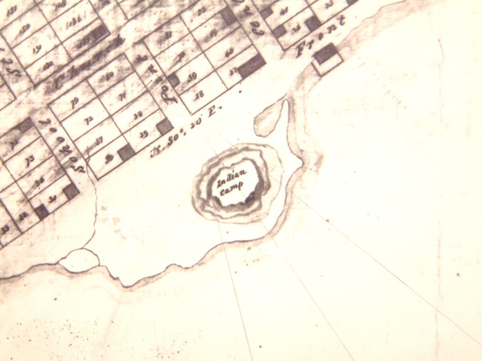
1816 map showing “Indian Camp” on Mississauga Point, located at the foot of what is now Gore Street (National Map Collection)
The actual date of this burial ground is unknown, but it is possible that the burials occurred after European settlement as the description of what was found is not unlike one burial excavated at Fort Frontenac. The account that appeared in the November 11th, 1840 edition of the Kingston Chronicle and Gazette reads: “Indian Remains. — During the progress of some excavations making by the Marine Railway Company, on Mississauga Point, the remains from 15 to 20 Indians, with beads, knives, etc. have been found, imbedded about 10 inches below the original surface of the site of the battery. The bodies appear to have been severally wrapt in bark, the remains of which were found in close proximity to the undecayed portions of each skeleton.” Limited archaeological testing was done in the vicinity in 1985 and 1988, but no evidence of any further burials was located.
Belle Island
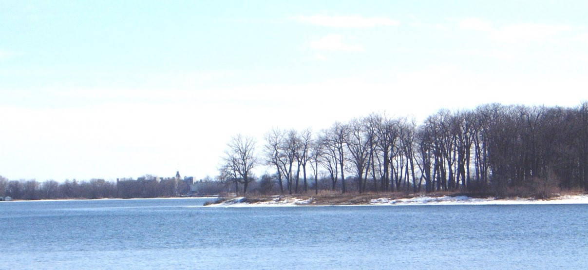
Belle Island today, in the Cataraqui River, adjacent to Belle Park Fairways on Montreal Street (Sue Bazely)
The burial ground on Belle Island is approximately 1000 years old. Although a hunting and fishing camp was known and had been archaeologically investigated, the burials were unknown until 1988. As part of the City’s archaeological master plan, the Cataraqui Archaeological Research Foundation tested parts of Belle Island. When Kingston’s Parks and Recreation Department bulldozed a nearby section of the shore to make a new beach for a day camp, it went through an area containing at least two human burials. Subsequent work in 1990 uncovered 7 burials: a young adult male in his 20s, two older males between 40 and 50, one of whom died as a result of a bone projectile point impacting the chest area, an adult female, an infant of 2-3 years, an infant of 2½ years, and a child of 3-4 years. All were re-interred close to the original location in 2000.
Historic Burial Grounds
Fort Frontenac
The French occupation of this area begins in 1673. The records at the archives of Notre Dame Church, Montreal, contain a register for the parish of St. Francis at Fort Frontenac for the period 1747 to 1751. The document is published in Preston and Lamontagne’s Royal Fort Frontenac and notes burials of native children and adults, French children and French adults. Presumably other men of the garrison and their families were also interred in the vicinity of the Fort during the late seventeenth and the eighteenth centuries until the fall of Fort Frontenac in 1758.
Military and Naval Burials
Kingston, as a military town, has always had a need to ensure the proper burial of members of both the British and, later, the Canadian forces. Although there are military entries in St. George’s burial register in the pre-1800 era, the increased number of military burials during the War of 1812 lead to the need for additional burial space. The St. George’s burial register for 1812 and 1813 records 60 named individuals (49th and 8th Regiment of Foot, Royal Newfoundland Fencibles, Glengarry Light Infantry, 10th Royal Veteran Battalion and a few sailors) and 20 un-named American prisoners-of-war. W.J. Patterson suggests that they were buried in the Garrison Burying Ground which by 1819 had become the Upper Burial Ground.
In addition to the Garrison Burying Ground, there are at least two other locations on ordnance and naval property, now part of the Royal Military College. Although they are marked on historical plans and may have been used either during the War of 1812 or the various epidemics in the 1830s, there is no other documentary record of the burials.
St. Joseph’s Cemetery
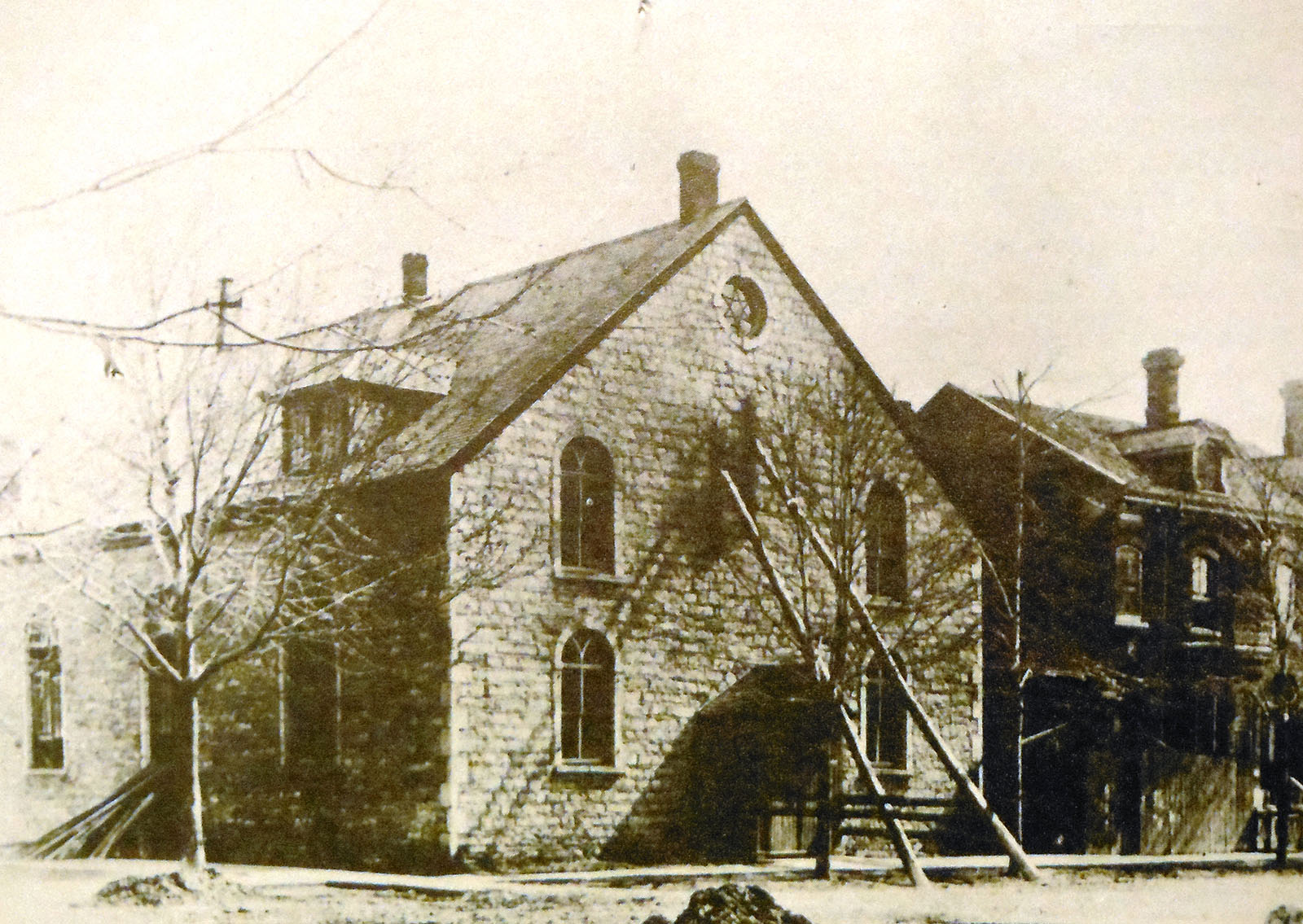
St. Joseph’s Roman Catholic Church, c1880, built at the corner of William and Bagot Streets (Queen’s University Archives)
This second Roman Catholic cemetery (the first being at Fort Frontenac) was located on Bagot Street adjacent to St. Joseph’s Church. The church was established around 1808, but the cemetery may have predated the construction of the church. The cemetery seems to have been in use until about 1825. The building itself ceased to be a church in 1859 but survived as a school until c1890. The cemetery was all but forgotten until the 1975 construction of a seniors’ apartment. According to newspaper articles 60 burials were removed by the workmen. No archaeological work has been undertaken in the area.
Upper Burial Ground
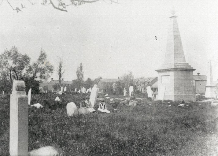
Upper Burial Ground (1893, prior to the establishment of the park) showing the Barclay monument (Queen’s University Archives)
A Garrison Burying Ground is shown on an 1816 map (but probably in use earlier) in the area now known as McBurney Park, bounded by Alma, Ordnance and Balaclava Streets. Three years later, it became a burial ground for Anglicans and Catholics. Known by 1825 as the Common or Upper Burial Ground, it was expanded to four acres to accommodate a section for Presbyterians. Most Kingston families buried their dead here but, by the 1850s, it was at capacity. The city’s dead were being buried in a new non-denominational cemetery at Cataraqui and in St. Mary’s Catholic Cemetery, Kingston. Closed in 1864 and increasingly neglected, the burying grounds became a public disgrace and, in 1893, were converted into a city park. Many remains and markers were removed to St.Mary’s and Cataraqui cemeteries, but the Barclay monument of 1826 was left in place. Landscaped with trees and walkways, it was named Frontenac and now McBurney Park, after former Central Public School Principal, James A. McBurney. Its informal name, Skeleton Park, is still in use.
No records of the burials in the Upper Burial Ground have survived. However, for those whose remains were transferred to St. Mary’s and Cataraqui cemeteries, there is a record of the re-burials.
Archaeological research has been done for the City of Kingston to ensure that the graves of the Upper Burial Ground are not disturbed when excavating is necessary. The City of Kingston retains copies of these reports.
Herchmer’s Grave Yard
Although there have been a number of family grave yards, most of them were in the more rural areas of Frontenac County. Herchmer’s grave yard was on farm lot 24 in concession 1, approximately at the corner of University Avenue and Stuart Street on which Ban Righ Hall was built in 1925. Farm lot 24 was a Loyalist grant to Johan Jost Herkimer. Johan Jost’s grandson, the Reverend William Macaulay Herchmer, was an assistant at St. George’s Church and the first priest for St. Paul’s Church. St. George’s register records some burials in Herchmer’s private grave yard. The City of Kingston’s Master Plan of Archaeological Resources Technical Report (2009) refers to twelve broken stones that were found at 127 King Street West in 1978. They were said to have been laid down as flagstones in a garden walk sometime during the 1930s. The report notes that their origin is unknown but goes on to hypothesize that they may have been from the Catholic section of the Upper Burial Ground. The names were predominately of Irish origin, and the burials commemorated date from between 1848 and 1885. Further research may show that they were originally part of Herchmer’s Grave Yard which is a very short distance north of 127 King Street West.
Union Cemetery
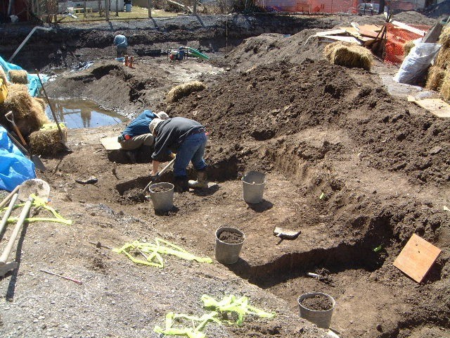
Excavation of the Union Cemetery in 2002 by the Cataraqui Archaeological Research Foundation
In 1827, Congregationalists purchased property in the present location of the Bethel Congregational Church of Kingston, located at 314 Johnson St., to serve as a cemetery for all non-conformist denominations (Baptists, Congregationalists and Ana-Baptists). The cemetery was in use until 1875, and in 1878, the Second Congregationalist Church, also known as Bethel Church, was constructed on the site of the Union Cemetery. Construction of an addition to the church in 2002 led to the discovery of human remains. There are no records for the Union Cemetery.
Current Cemeteries
Cataraqui Cemetery

Decorative monument in Cataraqui Cemetery, early 1900s (Collection John Grenville)
By mid-century the existing cemeteries were becoming full. The Cataraqui Cemetery was incorporated in 1850 to build a not for profit, non-denominational, rural reform public garden cemetery. The need for burial space became even more urgent when the City of Kingston passed a by-law in 1864 preventing burials within the city limits. Jennifer McKendry has written an excellent history of the cemetery – Weep Not for Me: A Photographic Essay and History of Cataraqui Cemetery (1995). The Cataraqui Cemetery Company also has a website with a short history of the site. The interment records are quite complete (including transfers from the Upper Burial Ground) and can be examined at the cemetery by appointment. Plans to put the records on-line are in progress.
St. Mary’s Roman Catholic Cemetery
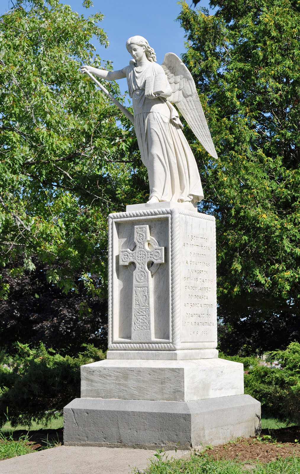
Angel of Resurrection in St. Mary’s Cemetery at Kingscourt Avenue and Kirkpatrick Street (credit Jennifer McKendry)
St. Mary’s Cemetery was part of farm lot 24 in the second concession of Kingston Township, now within the city limits at 718 Division Street. This was the fourth graveyard for the burial of Roman Catholics – Fort Frontenac during the French regime, St. Joseph’s Churchyard, the Upper Burial Ground and finally St. Mary’s Cemetery beginning in 1856. There were also about 40 people including all of the 19th century bishops from Macdonell to Cleary buried under St. Mary’s Cathedral. Once St. Mary’s Cemetery was operational some families moved bodies and tombstones from the Upper Burial Ground, especially after 1864 when the City passed a by-law that forbade burials within the city limits and in 1892 when the City of Kingston asked that the bodies and tombstones to be removed so that the Upper Burial Ground could be re-landscaped for a park. The plot cards and interment records have been microfilmed and are available at Queen’s University Archives.
Within the cemetery is the Angel of Mercy (also known as the Angel of the Resurrection) which was erected to mark the grave site of 1,400 Irish immigrants who died during the massive typhus epidemic in 1847. They were originally buried in a mass grave on the grounds of the Kingston General Hospital. The bodies and monument were removed from their original site and placed within St. Mary’s Cemetery in 1966.
Information for this section was taken from Rosemary Gibson’s “A Brief History of St. Mary’s Cemetery” which was printed in the Ontario Genealogical Society (Kingston Branch) 1986 publication on St. Mary’s Roman Catholic Cemetery.
Beth Israel Cemetery
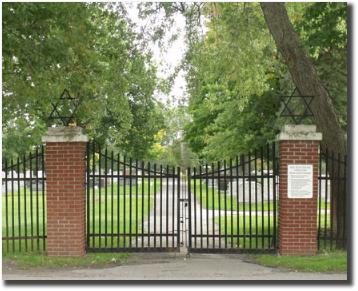
Gates to the Beth Israel Cemetery (Beth Israel website)
Documented Jewish presence in Kingston dates from the middle of the 19th century. The Beth Israel Cemetery was founded in 1897 to meet the needs of the Kingston and area Jewish community. It is located on the east side of Sydenham Road (between Princess Street and Arnold Street), adjacent to Cataraqui Cemetery. Further information is available at the Beth Israel website.